Advanced doesn’t need to be complicated - Unlock opportunity with your one-stop solution
Shop Now & Pay later In 3 Easy Instalments
NationWide Delivery
Order Online & Safely Collect In Store


Add ADK Repair & Maintenance Plan
Take every flight with confidence knowing your drone has crash protection and is kept in optimum flying condition
Get Your Drone Flying License
Wheather you are flying as a hobbyist or commercially, let our experienced drone flying instructors help you take your drone to the sky’s with ease.
UgCS ENTERPRISE
Get It Now, Pay Later
Free Delivery Nationwide On Orders Over R1999
Collect Safely Instore
Product Description
UgCS ENTERPRISE unlocks the full capability of UgCS, including all the features of UgCS PRO and EXPERT with the addition of UgCS ENTERPRISE exclusive features such as multi-node deployment and live video streaming.
It is designed for deployment on small and large scale companies employing drone pilots for various purposes such as infrastructure surveillance, security, law enforcement, aerial video monitoring, LiDAR data collection and other purposes. It is also used by professional drone pilots and search and rescue (SAR) teams who require video streaming.
Discover why UgCS ENTERPRISE is the top choice for small and large scale companies using drones.
Exclusive features of UgCS ENTERPRISE
- Run a centralized UgCS telemetry and video server and have pilots from the field connect over a VPN
- Live video streaming from UgCS for DJI to UgCS Video Player on Desktop
- Local video recording embedded metadata (geolocation, timestamp, vehicle ID and other)
- Video live streaming over RTSP to VMS (such as Luxriot, Milestone)
- Multiple SDK connections
- *ADS-B Transponder support
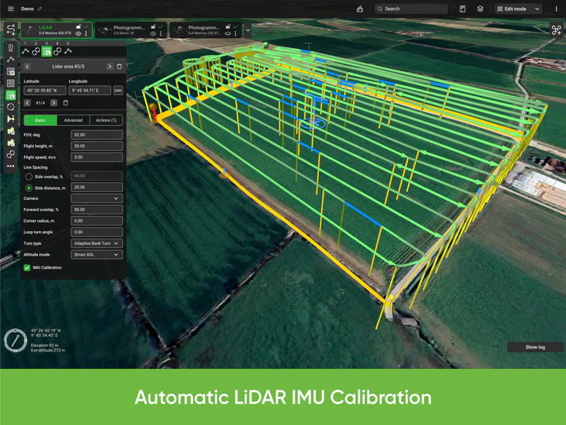
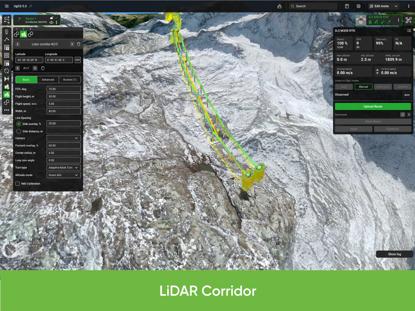
Features of UgCS ENTERPRISE for LiDAR surveys
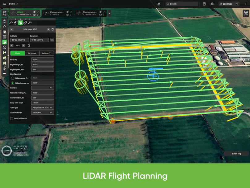
- LiDAR Area and LiDAR Corridor tools
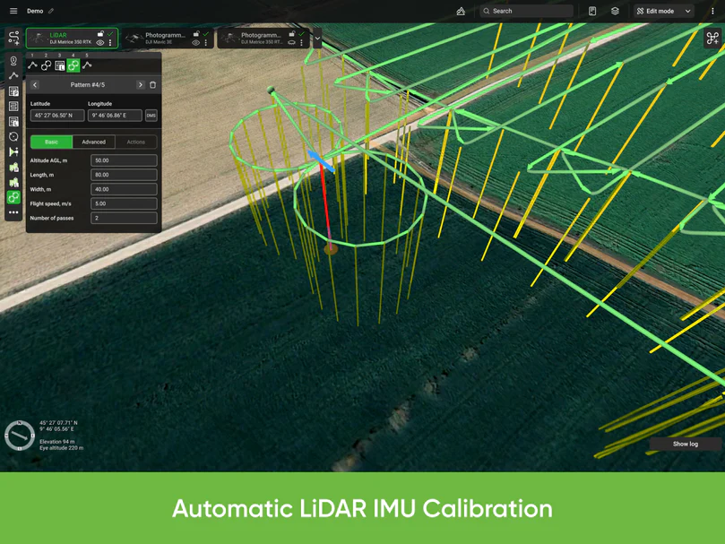
- IMU Calibration route pattern (figure eight)
- IMU Calibration actions (figure eight, U-turn/J-hook)
- LiDAR flight planning based on FOV value
- Adjustable corner radius for smooth cornering
- Loop turns for additional IMU calibration
- Smart AGL algorithm
- Adjustable LiDAR area buffer size
Other features of UgCS ENTERPRISE
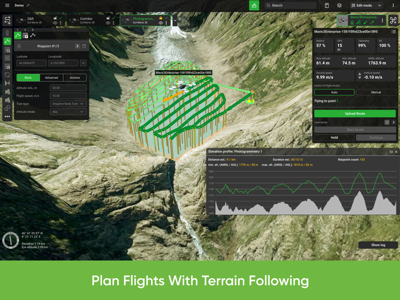
- Plan flights with terrain following
- 3D flight planning interface
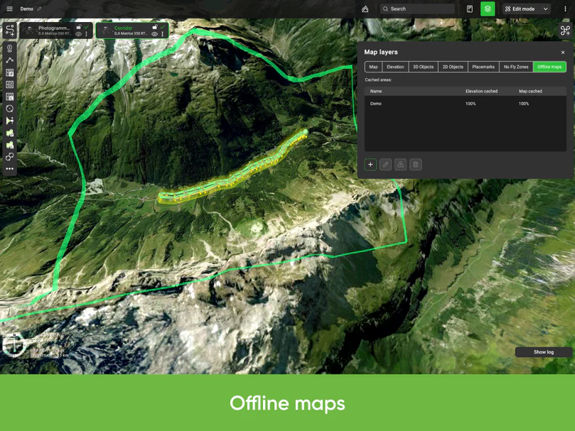
- Offline maps (fly without internet connection)
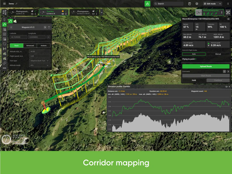
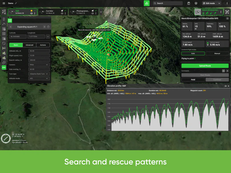
- Photogrammetry, Vertical (Facade) scan, Circlegrammetry, Corridor mapping, SAR, Linear, Circle, Waypoint, Perimeter, Area Scan flight planning tools
- Route import from KML/CSV data
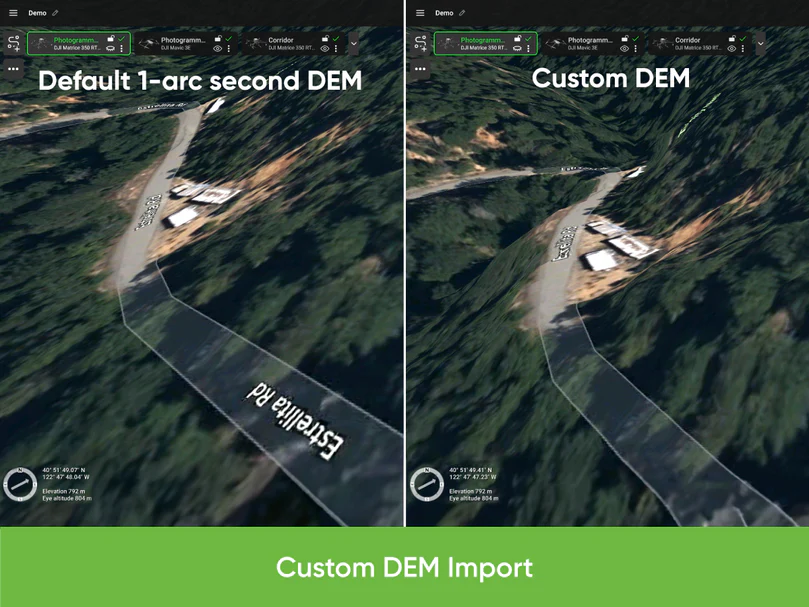
- DEM/DSM elevation data import from .TIF format
- Preview flights with respect to terrain elevation profile
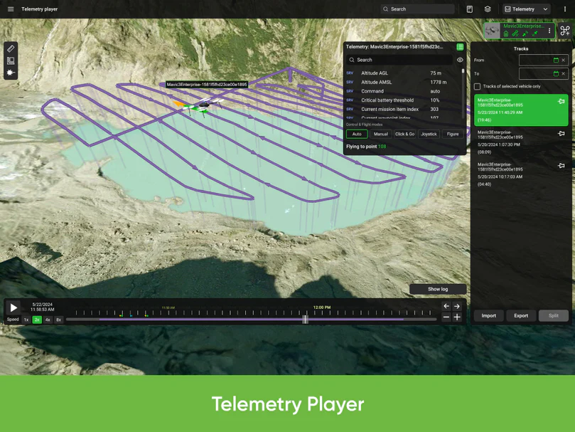
- Automatic telemetry recording
- Geo-referenced image import
- Create custom no-fly zones (NFZ)
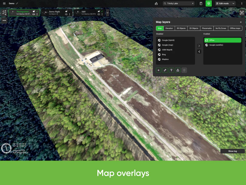
- Custom map overlays
- ADS-B Receiver support
- Compatible with UgCS Mapper to process images and create map overlays
- UgCS supports most popular UAV platforms including DJI M300, M350, M600, M2X0, Inspire, Phantom series, Mavic series.
UgCS ENTERPRISE perpetual license
- Buy once, own forever
- First year of support and updates is included
- Starting from the second year, an annual Support & Update pack needs to be purchased to get access to support and the latest updates.
Technical details
- Installs locally on your Windows computer
- Android app UgCS for DJI is used to connect to DJI drones


Register to receive an email when stock arrives.
UgCS ENTERPRISE Product Inquiry
Drone Licencing Training Inquiry
Repair/Maintenance Care Plan
Same Day Delivery
Order before 9:00am and receive your parcel before 17:00 (JHB & PTA)
*If you order on Friday after 09:00am your parcel will be collected and delivered on Monday
Local Overnight (JHB & PTA)
Order before 13:00 and receive your parcel the next day
*If you order on Friday your parcel will be collected on Monday and delivered on Tuesday.
Nationwide Deliveries
Order before 13:00. Turnaround delivery time 1-3 days
*No delivery services available on weekends. Parcels are collected on Mondays.
Collect Safely Instore
Pre order and collect safely from our store, and get to meet our aweseome drone team