Advanced doesn’t need to be complicated - Unlock opportunity with your one-stop solution
Shop Now & Pay later In 3 Easy Instalments
NationWide Delivery
Order Online & Safely Collect In Store
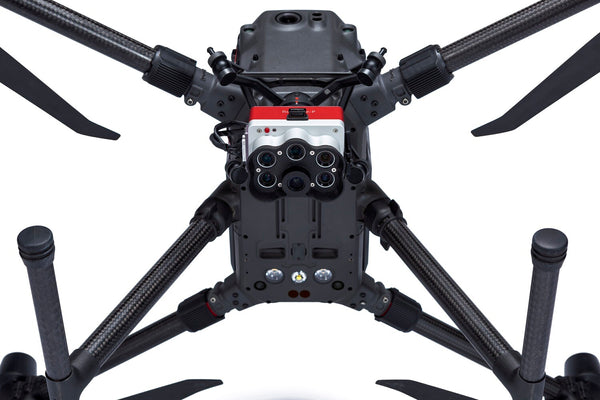
- High-resolution panchromatic band for pan-sharpened output
- Resolutions of 2cm 0.8″ at (60m)
- Five spectral bands for multiple vegetation indices and composites
- New professional removable storage standard in CFexpress, enabling up to three captures per second for faster flight speeds, cutting down on time required to map an area
- Electrical and mechanical interfaces compatible with existing RedEdge installations with just a connector upgrade
COMPATIBILITY
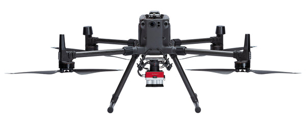
Designed for use with: DJI Matrice 300
Add ADK Repair & Maintenance Plan
Take every flight with confidence knowing your drone has crash protection and is kept in optimum flying condition
Get Your Drone Flying License
Wheather you are flying as a hobbyist or commercially, let our experienced drone flying instructors help you take your drone to the sky’s with ease.
Micasense (RedEdge-P Multispectral Kit + DJI Skyport for M300)
Get It Now, Pay Later
Free Delivery Nationwide On Orders Over R1999
Collect Safely Instore
Product Description
About MicaSense RedEdge-P
The New Standard for Data Quality and Repeatability
RedEdge-P uses purpose-built optics and industrial image sensors coupled with narrowband, scientific-grade filters. In addition, it undergoes a rigorous factory calibration process, creating a high-quality, calibrated, rugged tool for high-quality outputs.
The Ultimate Solution for High-Res RGB and Multispectral Data
Increased Storage
New professional removable storage standard in CFexpress, enabling over two captures per second and the immediate turnaround time between flights by simply swapping cards.
Synchronized Capture of High-Res RGB and Multispectral
Simultaneous capture of up to six bands, enabling multiple high-resolution outputs such as RGB, crop vigor indices (NDVI, NDRE, etc), and high resolution panchromatic.
Twice The Spatial Resolution of The Previous Rededge
With a high-resolution panchromatic imager, RedEdge-P enables higher-resolution RGB and multispectral outputs – 2cm resolution when flying at 60m. Spot smaller problems or features sooner and make more reliable management decisions across a variety of use cases.
Works with What You Have (Drones, Processing, Flight Planning)
This solution is compatible with a wide range of aircraft, from large, fixed wings to small multirotor. Flight planning and data processing can be done with industry-standard tools.
Rugged Design
IP4X rated for dust and splash protection.
The Industry Standard Multispectral Sensor
Providing a comprehensive view into crop health.
Plant Counting
Plant counting algorithms require high-resolution imagery. RedEdge-P combines a Panchromatic lens with 5-high-res multispectral lenses enabling high-res RGB and multispectral outputs, allowing plant count even at early growth stages.
Disease Identification
RedEdge-P captures a critical part of the light spectrum for studying plants (712-722 nm), called the red edge band. It is in this section of the spectrum that the first signs of stress start to show. Using analytics generated with the red edge band, it is possible to identify disease sooner and act faster to stop the spread.
Phenotyping
Manually measuring plant characteristics is time-consuming. RedEdge-P band combination enables high-resolution multispectral outputs, allowing the detection of variability at the leaf level.
Species Differentiation
Some differences among species may not be visible to the naked eye. High-res multispectral data allows for species differentiation, weeds included, by highlighting characteristics such as chlorophyll content, vigor, and leaf size.
Plant Health Mapping
RedEdge-P’s high-resolution multispectral outputs allow the generation of indices and composites to see individual chlorophyll levels in the plants and compare over time.
Advanced Crop Scouting
High-res multispectral and RGB imagery provides advanced field scouting capabilities. In one flight, it is possible to collect accurate and geotagged information of a problem, making it easy to assess the situation and determine the appropriate intervention.
Fertilizer Management
RedEdge-P’s high-res and accurate outputs allow easy identification of areas low in nutrients and help monitor the effects of fertilizer applications throughout the season and determine if, when, and where a new application is needed.
High-Res 3d Point Clouds
RedEdge-P’s 5.1-Megapixel panchromatic band provides over twice the ground resolution of the industry-standard RedEdge-MX, resulting in 3D point clouds with up to 4 times the point density.
Calibrated Multispectral Imagery
CRP 2 A new compact version of our Calibrated Reflectance Panel. Same functionality, now in a smaller size and easier to carry!
DLS 2 Our next-generation light sensor, with cutting-edge technology for irradiance and sun angle measurements. It provides more accurate, reliable data, greatly reduces the need for post-processing, and substantially improves radiometric accuracy. With the integrated GPS, setup with any aircraft is simple.
The Same Narrow Bands, at Twice the Resolution
This solution offers a seamless way to capture not just standard spectral bands but at a spatial resolution that takes it a step further. With a high-resolution panchromatic imager, RedEdge-P enables higher-resolution RGB and multispectral outputs – 2cm resolution when flying at 60m.
Micasense Increases Data Accuracy and Repeatability
You know the benefits of forecasting and data precision. We have a focus on accuracy and repeatability in our data and analysis, so that you can trust the data we help you gather.
Drone Licencing Training Inquiry
Important
Remotely operated hobby or toy aircraft and drone flying rules:
- • Do not, through act or omission, endanger the safety of any aircraft or person therein or any person or property through the negligent operation of any drone or remotely piloted aircraft, or model aircraft.
- • Fly or operate a drone or remotely piloted aircraft, toy or model aircraft 50 m or closer to:
- • any person or group of persons, on sports fields, road races, at schools or any social events.
- • any property without permission from the property owner.
Unless approved by the SACAA, do not fly or operate a drone, remotely piloted aircraft, toy or model aircraft:
- • near manned aircraft.
- • 10km or closer to an aerodrome which includes an airport, helipad or airfield.
- • a drone that weighs more than 7 kilograms (15.4 pounds), for which you don’t have a license.
- • in controlled airspace.
- • in restricted airspace.
- • in prohibited airspace.
Do not fly or operate a drone or remotely piloted aircraft, toy or model aircraft higher than (120m) 400 ft from the ground, unless approved by the Director of Civil Aviation of the SACAA.
General Basic Drone Flying Rules to which you must adhere:
- • You may not fly a drone within 10km of an airport.
- • You may not fly nearer than 50 metres from people, buildings or roads.
- • You may not fly a drone higher than 120m (400 feet).
- • ‘Hobby’ drones must be flown in within the line of sight.
- • Drones may not be flown at night.
Always fly your drone within your line of sight and below the highest obstacle in your vicinity.
For more information please see:
https://drone-laws.com/drone-laws-in-south-africa/
Register to receive an email when stock arrives.
Micasense (RedEdge-P Multispectral Kit + DJI Skyport for M300) Product Inquiry
Drone Licencing Training Inquiry
Repair/Maintenance Care Plan
Same Day Delivery
Order before 9:00am and receive your parcel before 17:00 (JHB & PTA)
*If you order on Friday after 09:00am your parcel will be collected and delivered on Monday
Local Overnight (JHB & PTA)
Order before 13:00 and receive your parcel the next day
*If you order on Friday your parcel will be collected on Monday and delivered on Tuesday.
Nationwide Deliveries
Order before 13:00. Turnaround delivery time 1-3 days
*No delivery services available on weekends. Parcels are collected on Mondays.
Collect Safely Instore
Pre order and collect safely from our store, and get to meet our aweseome drone team


