Mapping Africa from the Air: DJI Matrice 400 RTK and Zenmuse L3 LiDAR
Across Africa, infrastructure development, resource management, and land monitoring are expanding at an unprecedented pace. From large mining concessions in Zimbabwe to power transmission corridors across South Africa, the scale and complexity of these environments demand faster, safer and more accurate surveying tools.
Traditional ground-based surveys often struggle to keep pace with these demands. Teams must cover vast distances, navigate difficult terrain, and operate in environments where safety and accessibility can be constant challenges.
This is where aerial mapping technology is transforming the equation.
The combination of the DJI Matrice 400 RTK (M400) long-endurance drone platform and the Zenmuse L3 LiDAR system represents a next-generation solution for high-efficiency surveying, infrastructure inspection, and large-scale 3D modelling. Together, they enable organisations to capture highly detailed geospatial data faster than ever before, even across remote or complex environments.
For industries operating across Southern Africa, from utilities and engineering firms to mining operators and environmental planners, this pairing unlocks a powerful new standard for aerial mapping.

Why Advanced Aerial Mapping Matters in Africa
Many of Africa’s largest infrastructure and resource projects span vast, often remote landscapes.
Transmission lines stretch across hundreds of kilometres of rugged terrain. Mining operations require continuous monitoring of pits, tailings facilities and haul roads. Conservation areas and agricultural zones demand accurate terrain data for planning and land management.
In these environments, traditional surveying methods can be slow, labour-intensive and costly.
Drone-based mapping platforms are increasingly filling this gap by enabling organisations to capture high-resolution spatial data rapidly and safely from the air.
With the right equipment, a single drone flight can generate detailed 3D models, terrain maps and inspection data that would otherwise take days or weeks to collect.
The Matrice 400 RTK paired with Zenmuse L3 is designed precisely for these kinds of missions.

DJI Matrice 400 RTK: Built for Large-Scale Survey Operations
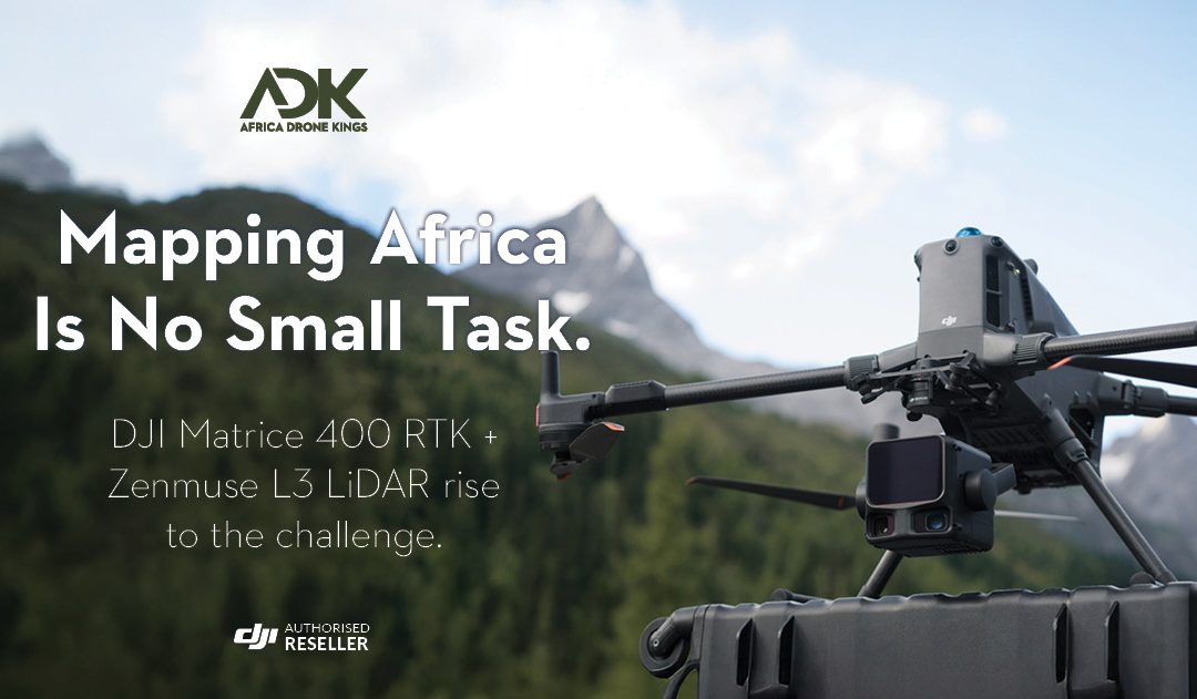
At the centre of this system is the DJI Matrice 400 RTK, DJI’s enterprise flagship drone platform engineered for versatility, endurance and mission-critical reliability.
The Matrice 400 offers an impressive 59-minute maximum flight time, allowing operators to cover significantly larger areas during each mission. Combined with a payload capacity of up to 6 kg, the aircraft supports a wide range of sensors and mapping payloads depending on operational requirements.
One of the platform’s most relevant capabilities in the African context is its advanced power-line-level obstacle sensing system.
Using integrated rotating LiDAR and mmWave radar, the Matrice 400 can detect thin obstacles such as power lines and branches during flight, improving navigation safety when operating near transmission infrastructure, dense vegetation or complex construction environments.
When paired with payloads such as the Zenmuse L3 LiDAR system, these environments can then be mapped in high detail for surveying and inspection purposes.
The platform also incorporates O4 Enterprise Enhanced Video Transmission and Airborne Relay Video Transmission, ensuring stable connectivity across long distances and difficult terrain.
Beyond surveying, the Matrice 400 is built to support a broad range of professional missions. Depending on the task, it can be equipped with a range of payload options including:
- Zenmuse H30 Series
- Zenmuse L2 LiDAR
- Zenmuse P1 mapping camera
- Zenmuse L3 LiDAR
- S1 Spotlight
- V1 Speaker
- Manifold 3 onboard computing module
- Third-party payload integrations
This modular design allows organisations to deploy a single aircraft platform across multiple operational scenarios including infrastructure inspection, mapping, emergency response and construction monitoring.

Zenmuse L3 LiDAR: High-Efficiency 3D Mapping at Scale
When paired with the Zenmuse L3, the Matrice 400 becomes a powerful aerial surveying platform capable of capturing high-precision geospatial data across vast areas.
The Zenmuse L3 is DJI’s first long-range, high-accuracy aerial LiDAR system, designed to deliver survey-grade mapping performance in a compact and highly integrated payload.
At the heart of the system is a 1535 nm long-range LiDAR sensor capable of detecting objects up to 950 metres away, even on surfaces with as little as 10% reflectivity. This long-range capability makes it ideal for surveying large landscapes, infrastructure corridors and dense vegetation.
To accelerate data acquisition, the Zenmuse L3 integrates dual 100 MP RGB mapping cameras alongside the LiDAR system. These cameras capture high-resolution imagery simultaneously with LiDAR point cloud data, enabling faster and more detailed spatial reconstruction.
The payload also includes a high-precision Position and Orientation System (POS), ensuring accurate geospatial positioning during flight. Combined with the system’s high pulse rate and advanced sensing capabilities, this enables highly detailed mapping of complex structures including power lines, transmission towers, vegetation and terrain features.
Together, these capabilities allow operators to generate highly accurate digital terrain models, point clouds and 3D maps with remarkable efficiency.
Under optimal mission conditions, the Zenmuse L3 can support daily mapping coverage of up to approximately 100 km², depending on flight altitude, terrain complexity and mission parameters.

Real-World Applications Across Southern Africa
The combination of Matrice 400 RTK and Zenmuse L3 opens up a wide range of practical applications across industries operating in Southern Africa.
1 – Powerline and Infrastructure Inspection
South Africa’s electricity grid spans vast distances across varied terrain. Surveying these corridors traditionally requires extensive field work.
With the Matrice 400’s power-line-level obstacle sensing and the Zenmuse L3’s high-accuracy LiDAR mapping, operators can inspect transmission corridors safely from the air while capturing detailed structural and terrain data.
This allows utilities to identify vegetation encroachment, infrastructure damage and potential risk areas much faster than traditional inspection methods.
2 – Mining and Resource Management
Zimbabwe and South Africa both host major mining operations that require continuous site monitoring.
The Matrice 400 and Zenmuse L3 combination allows mining operators to rapidly generate:
- High-resolution terrain models
- Stockpile volume calculations
- Pit progression analysis
- Tailings facility monitoring
- Haul road mapping
Because LiDAR pulses can penetrate gaps in vegetation canopy and capture ground returns beneath trees, the system can produce accurate terrain models even in areas where traditional photogrammetry may struggle.
3 – Large-Scale Land Surveying
Surveying large agricultural or conservation landscapes can be extremely time-consuming using conventional methods.
With the Zenmuse L3, operators can capture detailed LiDAR data across thousands of hectares in a single day, dramatically reducing the time required to produce accurate terrain models.
This is particularly useful for:
- irrigation planning
- watershed analysis
- agricultural land development
- environmental monitoring
4 – Construction and AEC Mapping
Across Africa, major infrastructure projects such as roads, rail corridors and urban development projects require accurate and frequent surveying.
The Matrice 400 RTK provides stable flight performance and long endurance for large project areas, while the Zenmuse L3 delivers precise 3D mapping data for planning, progress monitoring and digital modelling.
This combination enables engineers and planners to generate highly detailed 3D models and digital twins of construction environments.
The Mining Industry
In mining, where time quite literally equals money, the Matrice 400 RTK paired with the Zenmuse L3 becomes more than just a mapping tool, it turns into a daily decision-making asset.
Think about the constant need to track pit progression, measure stockpile volumes, and monitor tailings facilities, all while keeping teams safe and operations running smoothly. Instead of sending crews into active or hazardous zones, this system captures high-resolution terrain data from above, even cutting through light vegetation to reveal accurate ground models.
The result? Faster surveys, tighter reporting cycles, and data you can actually trust when planning the next blast, haul route, or expansion phase. It’s not just about seeing the site, it’s about understanding it in near real time, and that shift changes everything.
The Security Industry
In South Africa’s security landscape, where large-scale sites like mines, estates, and industrial parks stretch across kilometres of fencing and rugged terrain, response time is everything. This is where the combination of the Matrice 400 RTK and DJI Dock 3 starts to feel less like a tool and more like a fully fledged aerial security system. The dock acts as an always-ready launch station, housing, charging, and deploying the drone automatically when an alert is triggered. No scrambling for pilots, no delays. The moment a perimeter breach is detected, whether by electric fencing, thermal cameras, or ground sensors, the drone is airborne within seconds. From there, it feeds live video back to the control room, giving operators immediate visual confirmation of what’s actually happening on the ground.
Take a typical mining operation in Limpopo or the North West. These sites often deal with illegal mining activity, cable theft, and perimeter breaches, especially at night when visibility drops and ground patrols are stretched thin. With a Dock 3 setup, the response shifts completely. Instead of dispatching a vehicle blindly into a potentially dangerous situation, the drone is sent first. Equipped with thermal imaging and supported by LiDAR-based terrain awareness, it can track heat signatures moving through bush, identify vehicles parked in unusual zones, and even map escape routes in real time. Control room operators can then direct ground teams with precision, cutting response times and reducing risk. It’s not just faster, it’s smarter, and in many cases, it prevents escalation before it even begins.
You also start to see the ripple effect across the entire security operation. Patrol strategies become more data-driven. Instead of routine drive-arounds, teams respond to verified incidents. Fuel costs drop, vehicle wear decreases, and personnel are used more effectively. In high-end residential estates or commercial parks around Gauteng, this kind of setup is already changing expectations. Residents and tenants want faster, more reliable security, and aerial response delivers exactly that. Over time, the system builds a kind of operational memory, highlighting repeat intrusion points, vulnerable sections of perimeter, and patterns of movement that would be easy to miss from the ground. It’s a quiet shift, but a powerful one, where security becomes less about reacting and more about staying one step ahead.

Faster Data. Safer Surveys. Smarter Decisions.
One of the greatest advantages of aerial LiDAR systems is the ability to dramatically reduce the time, cost and risk associated with traditional surveying.
Instead of sending teams into hazardous terrain, steep slopes or remote infrastructure corridors, organisations can capture detailed geospatial data from the air.
The Matrice 400’s endurance, obstacle sensing and multi-payload capability combine with the Zenmuse L3’s long-range LiDAR performance to create a mapping platform designed for efficiency and safety.
For companies operating across Southern Africa’s vast landscapes, this translates into:
- Faster survey turnaround times
- Reduced labour and operational costs
- Safer data acquisition in hazardous environments
- Highly accurate 3D mapping outputs

Mapping the Future of Africa from the Air
As infrastructure development, environmental monitoring and resource management continue to expand across Africa, the demand for accurate and efficient spatial data will only grow.
The DJI Matrice 400 RTK paired with the Zenmuse L3 LiDAR system provides a powerful new solution for organisations that need to map larger areas faster and with greater accuracy.
From powerline inspections in South Africa to mining surveys in Zimbabwe, this next-generation aerial mapping platform enables professionals to capture the data they need to plan, build and manage the landscapes of tomorrow.
Contact us to learn more
If you’re looking to step up your surveying game or simply want to understand how aerial LiDAR can fit into your operation, now’s a good time to chat. Whether you’re working in mining, utilities, construction or land management, our team can help you figure out the right setup for your environment and goals.
From the DJI Matrice 400 RTK to the Zenmuse L3 and beyond, we’ll walk you through what matters, what works, and what’s worth the investment. Get hold of us to learn more, our professionals are ready to assist and help you map smarter, faster, and with real confidence.