Advanced doesn’t need to be complicated - Unlock opportunity with your one-stop solution
Shop Now & Pay later In 3 Easy Instalments
NationWide Delivery
Order Online & Safely Collect In Store
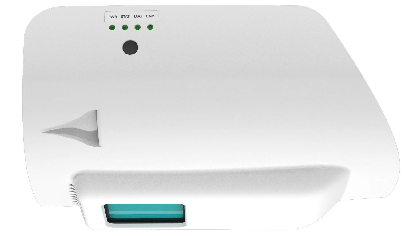
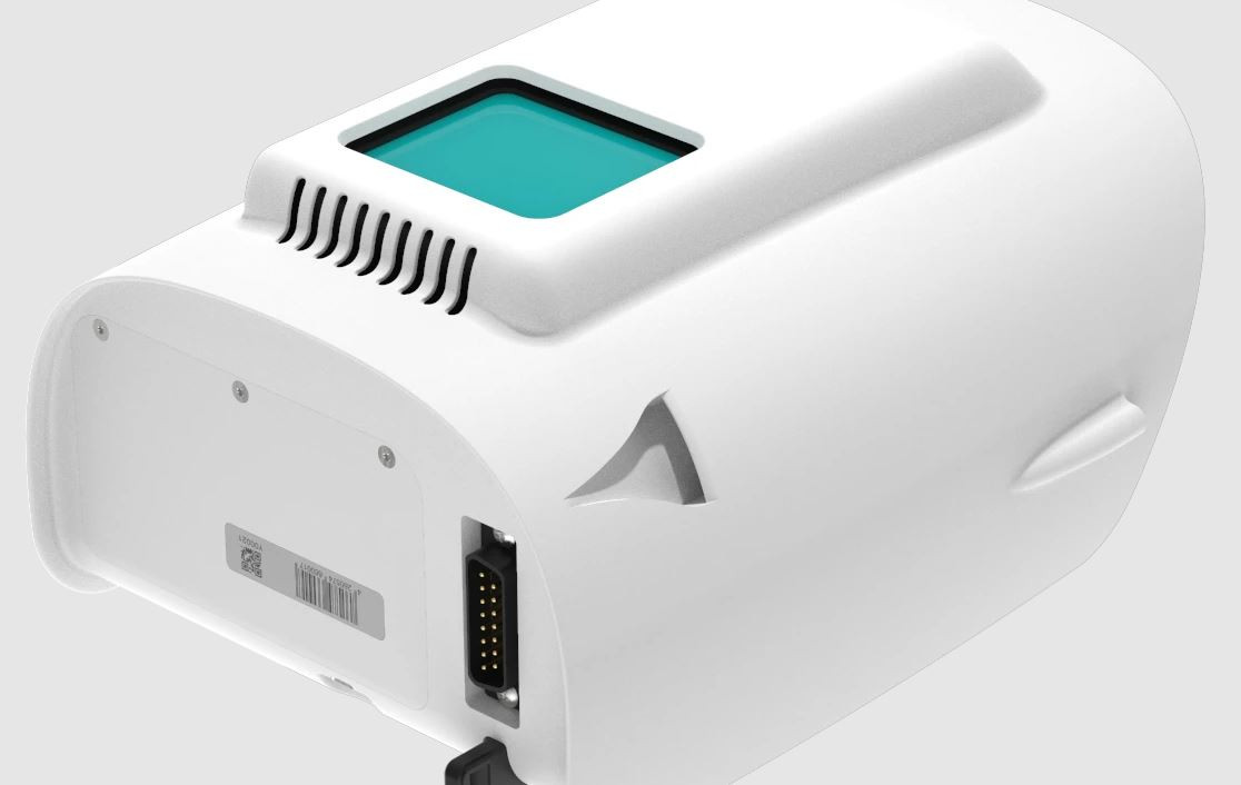
The Qube 240 payload is a geomatics grade LiDAR Scanner for the Trinity F90+ UAS and it endures up to 60 min of flight time with this combination. It is offered as a complete solution, all encompassed with YellowScan CloudStation Software pack, and license.
Quantum Qube 240 LiDAR Scanner
Get It Now, Pay Later
Free Delivery Nationwide On Orders Over R1999
Collect Safely Instore
Add ADK Repair & Maintenance Plan
Take every flight with confidence knowing your drone has crash protection and is kept in optimum flying condition
Get Your Drone Flying License
Wheather you are flying as a hobbyist or commercially, let our experienced drone flying instructors help you take your drone to the sky’s with ease.
Product Description
A geomatics grade, high-speed scanning LiDAR
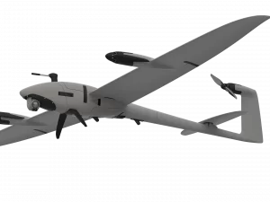
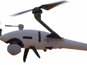
The Qube 240 payload is a geomatics grade LiDAR Scanner for the Trinity F90+ UAS and it endures up to 60 min of flight time with this combination. It is offered as a complete solution, all encompassed with YellowScan CloudStation Software pack, and license.
Light Ranging and Detection (LiDAR) sensors, partly traded as the key technology of the future for autonomous driving are also the first choice for highly productive survey tasks.
Until recently, LiDAR payloads were hardly affordable for SMEs due to their high cost. This is exactly where Quantum-Systems and YellowScan come in and offer a geomatics grade LiDAR scanner integrated into the payload compartment of the Trinity F90+ drone including software package without having to compromise on data quality.
A small and powerful LiDAR sensor for the Trinity F90+ UAS
The Qube 240 LiDAR sensor inherits the YellowScan Ultra Surveyor LiDAR scanner. This was the first integration into our Tron UAS platform in 2017. Advances in miniaturization and performance improvements across the board now increased range and accuracy with a significantly smaller form factor. This is impressively reflected in the cost reduction of over 50% for the overall system.
A geomatics grade LiDAR solution from a single source
The Qube 240 LiDAR provides essential information for surveying and mapping by generating an accurate 3D image of the process environment through 240,000 distance measurements per second.
Oustanding absolute accuracy is achieved with the help of the integrated Applanix APX15 INS. One can speak of a geodetic accuracy that was previously only achievable with LiDAR Systems of the upper price segment. The easy handling and user-friendly integration will convince customers. Fast and easy processing of the raw data is an additional benefit.
The solution comes with YellowScan CloudStation software which is enclosed in an adapted variant with a 1-year subscription license.
Features and availability of the Qube 240 LiDAR
The development and technical integration began in the second half of 2020 based on the cooperation with YellowScan. Which was already in years of existence. We achieved our goal to develop a geomatics-grade LiDAR sensor for our Trinity F90+ drone!
The result was a payload with unique key data:
- Geomatics Grade LiDAR
- Class 1 (Eye Safe)
- Wave length: 905 nm
- Maximum altitude: 140 m AGL
- Precision: 1.8-2.5 cm
- Accuracy: < 3 cm
- Scanner field of view: 70°
- 240,000 shots per second
- Point density @100m: 50-100 points/m²
- Multi-echo technology: up to 3 echoes per shot
- Applanix POSPacTM UAV, GNSS, and INS software for PPK
- Qube 240 data processing software to generate survey-grade LAS Files.
Key Benefits of the Qube 240 LiDAR Payload:
Efficient, high-resolution, and perfectly aligned
A perfect match of high-resolution point clouds surveyed with 5 parallel runs at 100m altitude above ground. The result shows the perfect alignment of the separate runs with an extremely low level of noise. The Trinity F90+ was mapping an area of 50ha in about 10 minutes of flight time.
Elevations surveyed without compromise
The elevation measured from 100m above ground. The excavator in the lower right corner is a good example to illustrate the resolution and precision of the Qube 240 LiDAR. The terrain, as well as buildings and vegetation such as trees, are also clearly visible.
Automatic classification of ground points
The bench of the quarry pond in the lower part of the images is clearly shown. The Qube 240 with 3 echoes and 240.000 points per second provides a great penetration of the vegetation and therefore this LiDAR system is the right tool to survey terrain covered by trees and bushes.
Clearly visible terrain and building structures by day and night
Dense Qube 240 point cloud colorized by intensity values showing the reflectance of the terrain or ground objects. The brighter the color the more reflectance of the LiDAR beams by the terrain, vegetation, or urban structures. The photovoltaic panels on the rooftops are clearly visible. The intensity values are completely independent of sunlight. Thanks to the fact that the LiDAR technology is an active sensor, mapping infrastructure and surveying large areas is also possible at night.
CAD reconstruction made easy
The point clouds captured by the Qube 240 are 100% survey grade and this example shows CAD reconstruction of buildings as used for 3D city models. Thanks also to our reseller ProgeaSky for their support in post-processing.

Register to receive an email when stock arrives.
Quantum Qube 240 LiDAR Scanner Product Inquiry
Drone Licencing Training Inquiry
Repair/Maintenance Care Plan
Same Day Delivery
Order before 9:00am and receive your parcel before 17:00 (JHB & PTA)
*If you order on Friday after 09:00am your parcel will be collected and delivered on Monday
Local Overnight (JHB & PTA)
Order before 13:00 and receive your parcel the next day
*If you order on Friday your parcel will be collected on Monday and delivered on Tuesday.
Nationwide Deliveries
Order before 13:00. Turnaround delivery time 1-3 days
*No delivery services available on weekends. Parcels are collected on Mondays.
Collect Safely Instore
Pre order and collect safely from our store, and get to meet our aweseome drone team
Important
Remotely operated hobby or toy aircraft and drone flying rules:
- • Do not, through act or omission, endanger the safety of any aircraft or person therein or any person or property through the negligent operation of any drone or remotely piloted aircraft, or model aircraft.
- • Fly or operate a drone or remotely piloted aircraft, toy or model aircraft 50 m or closer to:
- • any person or group of persons, on sports fields, road races, at schools or any social events.
- • any property without permission from the property owner.
Unless approved by the SACAA, do not fly or operate a drone, remotely piloted aircraft, toy or model aircraft:
- • near manned aircraft.
- • 10km or closer to an aerodrome which includes an airport, helipad or airfield.
- • a drone that weighs more than 7 kilograms (15.4 pounds), for which you don’t have a license.
- • in controlled airspace.
- • in restricted airspace.
- • in prohibited airspace.
Do not fly or operate a drone or remotely piloted aircraft, toy or model aircraft higher than (120m) 400 ft from the ground, unless approved by the Director of Civil Aviation of the SACAA.
General Basic Drone Flying Rules to which you must adhere:
- • You may not fly a drone within 10km of an airport.
- • You may not fly nearer than 50 metres from people, buildings or roads.
- • You may not fly a drone higher than 120m (400 feet).
- • ‘Hobby’ drones must be flown in within the line of sight.
- • Drones may not be flown at night.
Always fly your drone within your line of sight and below the highest obstacle in your vicinity.
For more information please see:
https://drone-laws.com/drone-laws-in-south-africa/