Advanced doesn’t need to be complicated - Unlock opportunity with your one-stop solution
Shop Now & Pay later In 3 Easy Instalments
NationWide Delivery
Order Online & Safely Collect In Store
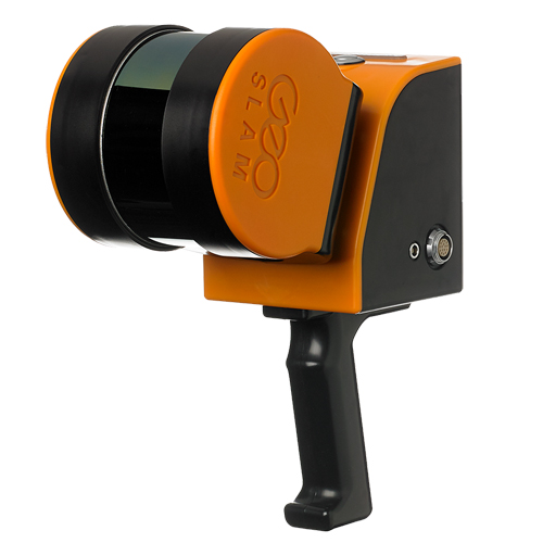


The GeoSLAM ZEB Horizon is a flexible LiDAR scanner that can be used indoors, outdoors and underground. A range of accessories (available separately) extend its usability and performance.
- UAV Mount: Mount the ZEB Horizon to drones like the DJI M300 RTK and M600.
- ZEB Discovery: LiDAR and high-resolution imagery from the ZEB Discovery with ultra-high definition imagery.
- ZEB Locate: Connect your point cloud to the real world, without the need for external control points.
- ZEB Vision: Attaches to the ZEB Horizon to capture colourised data and 360° panoramic images in minutes.
- Other Accessories: Mount to a car or use a cradle and pole to elevate or lower the ZEB Horizon.
(Including 1 Year of Software, UAV Mount for M300 RTK)
Add ADK Repair & Maintenance Plan
Take every flight with confidence knowing your drone has crash protection and is kept in optimum flying condition
Get Your Drone Flying License
Wheather you are flying as a hobbyist or commercially, let our experienced drone flying instructors help you take your drone to the sky’s with ease.
GeoSlam Lidar Camera (Including 1 Year of Software, UAV Mount for M300 RTK)
Get It Now, Pay Later
Free Delivery Nationwide On Orders Over R1999
Collect Safely Instore
Product Description
A handheld LiDAR scanner, suitable for drone mapping applications as well as indoor use. This powerful tool helps make the mapping process simple. With a range of 100m, the ZEB Horizon is great for outdoor use including spaces where features are positioned further apart.
Lightweight and rugged, simple to use, fast to capture and easy to process giving you the most accurate information you need to make the most important decisions. The ZEB Horizon is a complete 3D scanning solution for accurate, high quality and professional results.
The ZEB Horizon is as flexible as you are. Use handheld or pair with one of our many mounting options. Take your ZEB to the skies by mounting to a UAV or reach those difficult places with the cradle or pole.
Key features :
- Lightweight and compact for easy deployment
- 300,000 scanner points per second - conduct quality scans in less time
- 3D scanning with a survey grade relative accuracy of up to 6mm dependent on the environment
- 100m range
- Rotating LiDAR sensor for the widest field of view
- Use outdoors, indoors or underground. Mount it to a drone, a backpack or a vehicle.
- No additional positioning sensors required
- No need for GPS
- Uses powerful SLAM technology - perfect for mobile mapping
- See intensity values
- Flight plan according to the area, features and overlap
- Processing on site – data quality and coverage check
- Georeferencing possibility – checkerboard, spheres, white lines etc.
- Camera availability – Use the GeoSLAM ecosystem for point cloud colouring and mesh creation


Register to receive an email when stock arrives.
GeoSlam Lidar Camera (Including 1 Year of Software, UAV Mount for M300 RTK) Product Inquiry
Drone Licencing Training Inquiry
Repair/Maintenance Care Plan
Same Day Delivery
Order before 9:00am and receive your parcel before 17:00 (JHB & PTA)
*If you order on Friday after 09:00am your parcel will be collected and delivered on Monday
Local Overnight (JHB & PTA)
Order before 13:00 and receive your parcel the next day
*If you order on Friday your parcel will be collected on Monday and delivered on Tuesday.
Nationwide Deliveries
Order before 13:00. Turnaround delivery time 1-3 days
*No delivery services available on weekends. Parcels are collected on Mondays.
Collect Safely Instore
Pre order and collect safely from our store, and get to meet our aweseome drone team